
BioProtect Biodiversity Toolbox

The automated marine image annotation tool speeds up the analysis of seafloor imagery by turning simple point annotations into polygons that can train modern object‑detection models. It sits within the BIIGLE 2.0 platform and supports large scale benthic biodiversity monitoring.

Progress so far

In months 1–18, the project team designed and implemented a semi‑automated annotation pipeline inside BIIGLE 2.0, focused on converting legacy point annotations into high quality polygons.

Key work included:

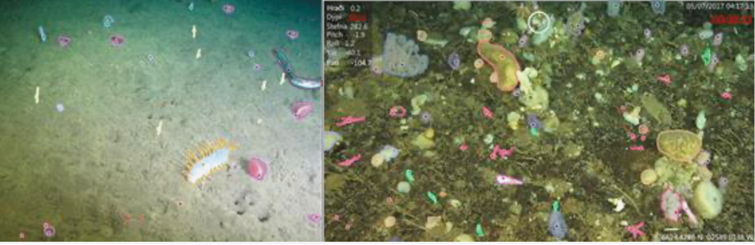
  • Developing a custom parser to ingest historical annotation datasets from the Icelandic demonstration site, covering 3,103 images and 3,831 point annotations.
  • Building a point‑to‑polygon conversion module combining tailored heuristics with the Segment Anything Model (SAM) to deal with challenges such as variable object size, thin organisms and dense scenes.
  • Running an initial validation phase that successfully converted 93% of the legacy points into polygons and initiating expert review of those polygons with project partners at MFRI.

The team also analysed label inconsistencies, image heterogeneity and conversion difficulties, and agreed to focus initial refinement on sparser images to stabilise model performance.

What this delivered

By M18, these activities produced the first prototype of a scalable annotation pipeline that can dramatically reduce expert time spent on drawing polygons. The tool is currently at TRL 4–5 and already integrated into BIIGLE 2.0, with export formats compatible with global biodiversity databases such as OBIS and GBIF.

Next steps

The next phase will curate the label scheme, train preliminary detectors, and run iterative human‑in‑the‑loop cycles, where experts validte machine‑generated annotations using BIIGLE’s LARGO tool. This will lead to a refined detector with documented performance and limitations, ready for wider use across BioProtect imagery streams..

Left: A sparsely populated image showing original point annotations (dots) and the resulting polygon conversions. Small and thin objects present a particular challenge for this process. Right: A densely populated image with points and polygon conversions. The high number and overlap of organisms in close proximity may pose challenges for both the conversion algorithm and subsequent object detection models.

The autonomous eDNA biosampler is a deployable device that filters seawater in situ, preserves eDNA directly on filters and cleans itself between samples, reducing manual handling and expanding where high‑quality eDNA data can be collected.

Progress so far

In the first 18 months, the team advanced the biosampler from concept towards a system that is filed-ready and able to operate at greater depths.

Main activities included:

  • Designing and manufacturing an intermediate‑depth pressure vessel using CAD and finite‑element analysis, followed by hyperbaric chamber tests to verify structural integrity and sealing.
  • Testing hydraulics and filtration performance between 2 and 10 bar (20–100 m depth equivalents) to confirm stable flow rates and identify optimisation needs.
  • Running controlled tank trials to compare programmed vs actual filtered volumes (target 2 L), with percentage errors around 3%, and optimising ethanol volumes needed to preserve filters while maintaining at least 70% ethanol inside Sterivex units.
  • Conducting cleaning protocol trials to determine how much 10% bleach and flush water are needed to sterilise internal lines while reducing wastewater and reagent use.
  • Carrying out initial field tests in the Marina of Leixões and coastal Porto waters, both as standalone and AUV‑mounted deployments, and comparing eDNA yields with manually collected samples.

These activities demonstrated that the system can collect and preserve eDNA in situ, with eDNA yields comparable to, or better than manual sampling and reduced variability.

What this delivered

By M18, BioProtect had an initial prototype biosampler validated in tank tests and shallow‑water field trials, with clear design parameters for preservation, cleaning and volume control. The system is now ready for deeper deployments and for testing against BioProtect’s target taxa in Portuguese and Icelandic waters.

Next steps

Between months 18–36, the project will alpha‑test the v1 sampler in the Portuguese demonstration site, increase the maximum operational depth to 1,000 m, and develop a second version that incorporates lessons learned, improved sample preservation and more efficient sterilisation. This v2 sampler will then be validated in laboratory, controlled sea and operational environments.

Design and pressure‑chamber testing of the autonomous eDNA biosampler pressure vessel to ensure safe operation at higher depths.

Field test images from July 2025 of the assembled autonomous eDNA biosampler (black cylinder) attached to an AUV.

The Azor drift‑cam is a low‑cost, deep‑sea camera system designed to map seafloor habitats down to roughly 1000 m, using off‑the‑shelf components and deployable from small vessels.

Progress so far

During the first 18 months, BioProtect worked with the existing Azor drift‑cam developers to assess and prepare the system for use in new regions.

Key activities were:

  • Documenting and learning from extensive Azores deployments (over 1000 dives, 980+ hours of video and more than 580 km of mapped seabed) and the associated biodiversity records.
  • Participating in a June 2025 field campaign in the Azores to gain hands‑on experience with deployment, live‑feed operations and data handling, and to discuss adaptations needed for Portugal‑North coast conditions.
  • Reviewing challenges linked to strong currents, complex topography and mobile sediments, and identifying technical and procedural adaptations for deployment from small fishing vessels.
  • Beginning procurement of hardware components for two new drift‑cam systems to be assembled and tested under local conditions off Aveiro.

This preparation work ensures that when the systems are assembled, our partners can move quickly into sea trials and collaborative surveys with local fishers.

What this delivered

By M18, BioProtect had confirmed the suitability of the Azor drift‑cam approach for the Portugal‑North demonstration site and laid the groundwork for assembling and tuning two new systems. This positions the toolbox to deliver cost‑effective deep‑sea imagery in new areas and to feed those data into automated annotation workflows.

Next steps

Upcoming work will assemble the new camera systems, run initial trials from the research vessel Nereide for calibration and procedure optimisation, and then move to deployments from local fishing vessels. This will test performance under real‑world conditions and integrate fishers’ knowledge into survey planning.

The Azor drift‑cam being deployed and operated in the Azores, providing a model for cost‑effective deep‑sea biodiversity mapping in BioProtect sites.

The citizen science eDNA sampler is a portable, battery‑powered device that allows non‑specialists to collect surface water samples for eDNA analysis, making biodiversity monitoring possible in places scientists rarely reach.

Progress so far

In the first 18 months, BioProtect adapted and deployed the Smith‑Root citizen science sampler in Iceland as part of an emerging community‑based monitoring network.

Key activities included:

  • Using the sampler to collect eDNA in eight harbours in West Iceland in 2024 and 2025, targeting invasive species and providing replicated harbour samples for later metabarcoding.
  • Supporting the “Great Icelandic Swim”, where the crew collected 60 surface samples every 15–20 nautical miles around Iceland using the same device, greatly expanding spatial coverage.
  • Developing simple instructions and workflows so that volunteers could collect approximately 2 L per sample, preserve filters appropriately and avoid contamination, with minimal training.
  • Samples from these campaigns are scheduled for metabarcoding analysis, which will generate occurrence data for a wide range of taxa.

What this delivered

By M18, the citizen science sampler had already been used successfully in real‑world conditions to generate a substantial set of eDNA samples from harbours and coastal waters around Iceland, demonstrating the feasibility and affordability of citizen‑driven biodiversity monitoring.

Next steps

The next phase will process the 2024–2025 samples using metabarcoding and will continue harbour sampling in subsequent years. The experience gained will inform how citizen science eDNA protocols can be scaled to other regions and communities.

Instruction for collecting eDNA samples, provided in the citizen science eDNA sampler manual (adapted from Smith-Root).

The VME‑ID app is a mobile application being developed to help fishers, observers and scientists record bycatch of VME indicator species such as sponges and corals, supporting better mapping of vulnerable marine ecosystems.

Progress so far

In the first 18 months of the project, BioProtect and GisGeo Information Systems initiated the design and development of the VME‑ID app.

Main activities were:

  • Reviewing existing citizen and bycatch reporting apps to identify useful features and gaps, with a focus on tools like GelAvista and Bycatch that inspired the design but cover different taxa.
  • Defining the technical architecture to ensure scalability, security and easy content management.
  • Designing user flows for registration, vessel profiling, taxa selection and bycatch reporting, including GPS‑linked records and support for offline data entry with later synchronisation.
  • Planning content for the species catalogue (images and descriptions of VME indicator taxa in the NEAFC area) and initial language coverage (Portuguese first, then Icelandic and English).


The application is still under active development, with beta release and testing planned in the next stages.

What this delivered

By M18, BioProtect had defined and begun implementing the VME‑ID app architecture and interface, creating a dedicated pathway for fishers and researchers to contribute geo-referenced records of VME indicator bycatch across the Northeast Atlantic.

Next steps

The next phases will finalise the Portuguese beta version, test it with at least three fishing vessels, three research vessels and 15 users, then incorporate feedback to deliver a final version in multiple languages. Interoperability with platforms such as OBIS and GBIF via Darwin Core standards is planned to support broader use.

Sample screenshots of the registration phase of the BioProtect VME-ID app mobile application (illustrative only).